Arunachal pradesh And It's Hisyory
ARUNACHAL PRADESH(History)
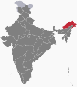
Arunachal Pradesh(English: /ˌɑːrəˌnɑːtʃəl prəˈdɛʃ/) is one of the 29 states of India and is the northeastern-most state of the country. Arunachal Pradesh borders the states of Assam and Nagaland to the south and shares international borders with Bhutan in the west, Myanmar in the east and is separated from China in the north by the disputed McMahon Line. Itanagar is the capital of the state.
A major part of the state is claimed by the Republic of China, and the People's Republic of China referring to it as "South Tibet". The major part of the state which is claimed by China, was temporarily occupied by Chinese forces during the 1962 war.[11]
Land of the Dawn-Lit Mountains is the sobriquet for the state in Sanskrit;[12] it is also known as the Orchid State of India or the Paradise of the Botanists. Geographically, it is the largest of the north-eastern states known as the Seven Sister States.
Early history
The history of pre-modern Arunachal Pradesh is unclear. According to the Arunachal Pradesh government, the Hindu texts Kalika Purana and Mahabharata mention the region as the Prabhu Mountains of the Puranas, and where sage Parashurama washed away sins, the sage Vyasa meditated, King Bhishmakafounded his kingdom, and Lord Krishnamarried his consort Rukmini.[13]
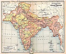
Recorded history from an outside perspective only became available in the Ahom and Chutiya chronicles. The Monpa and Sherdukpen do keep historical records of the existence of local chiefdoms in the northwest as well. Northwestern parts of this area came under the control of the Monpa kingdom of Monyul, which flourished between 500 B.C. and 600 A.D. The remaining parts of the state, especially those bordering Myanmar, were under the control of the Chutiya Kings until the Ahom-Chutiya battle in the 16th century. The Ahoms held the areas until the annexation of India by the British in 1858. However, most Arunachali tribes remained in practice largely autonomous up until Indian independence and the formalisation of indigenous administration in 1947.
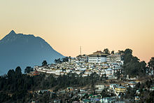
Recent excavations of ruins of Hindu temples, such as the 14th century Malinithan at the foot of the Siang hills in West Siang, indicate they were built during the Chutiya reign. Another notable heritage site, Bhismaknagar, has led to suggestions that the Idu (Mishmi) had an advanced culture and administration in prehistoric times. Again, however, no evidence directly associates Bhismaknagar with this or any other known culture but the Chutiya rulers held the areas around Bhismaknagar from the 12th to 16th century. The third heritage site, the 400-year-old Tawang Monastery in the extreme north-west of the state, provides some historical evidence of the Buddhist tribal people. The sixth Dalai Lama Tsangyang Gyatso was born in Tawang.
Drawing of McMahon line
In 1913–1914 representatives of China, Tibet and Britain met in India ending with the Simla Accord with Tibetan and British representatives agreeing on the McMahon Line.[14] However, the Chinese representatives refused the territory negotiation. This treaty's objective was to define the borders between Inner and Outer Tibet as well as between Outer Tibet and British India. British administrator, Sir Henry McMahon, drew up the 550 miles (890 km) McMahon Line as the border between British India and Outer Tibet during the Simla Conference. The Tibetan and British representatives at the conference agreed to the line, and Tawang and other areas ceded to the British Empire, since the British were not able to get an acceptance from China, Chinese considered the McMahon line invalid.[11] The Chinese representative refused to accept the agreement and walked out.[citation needed]
The Tibetan and British governments went ahead with the Simla Agreement and declared that the benefits of other articles of this treaty would not be bestowed on China as long as it stays out of the purview.[15] Tibet administered its territory until 1950. The Chinese position was that Tibet was not independent from China: Tibet could not have independently signed treaties, and per the Anglo-Chinese (1906) and Anglo-Russian (1907) conventions, any such agreement was invalid without Chinese assent.[16]
However, with the collapse of Chinese power in Tibet, the line had no serious challenges as Tibet had signed the convention. In 1935, a Deputy Secretary in the Foreign Department Olaf Caroe "discovered" that McMahon Line was not drawn on official maps. The Survey of India published a map showing the McMahon Line as the official boundary in 1937.[17]
In 1938, the British finally published the Simla Convention as a bilateral accord two decades after the Simla Conference; in 1938 the Survey of India published a detailed map showing Tawang as part of North-East Frontier Agency. In 1944 Britain established administrations in the area from Dirang Dzong in the west to Walong in the east.
The situation developed further as India became independent in 1947 and the People's Republic of China (PRC) was established in 1949. In November 1950, with the PRC poised to take over Tibet by force, India showed support for the Tibetan government to some extent irking the Chinese government. The McMahon Line was considered invalid by the Chinese government.[11] Journalist Sudha Ramachandran argued that China claims Tawang on behalf of Tibetans and Tibetans are not claiming Tawang to be Tibetan territory.[18]
The Dalai Lama was upset over Mao's "Cultural Revolution" which affected Tibet seriously. In January 2007, he said that in 1914 both the Tibetan government and Britain recognized the McMahon Line.[19] In 2008, he said that "Arunchal Pradesh was a part of India under the agreement signed by Tibetan and British representatives".[20] According to the Dalai Lama, "In 1962 during the India-China war, the People's Liberation Army (PLA) occupied all these areas (Arunachal Pradesh) but they announced a unilateral ceasefire and withdrew, accepting the current international boundary".[21]
Sino-Indian War
The NEFA (North-East Frontier Agency) was created in 1954. The issue was quiet for nearly a decade, with a period of cordial Sino-Indian relations, but its resurgence in 1960 was a factor leading to the Sino-Indian border conflict of 1962. During the war in 1962, China captured most of the area of Arunachal Pradesh. However, China soon declared victory, withdrew back to the McMahon Lineand returned Indian prisoners of war in 1963. It is believed by some commentators that Mao wanted to intimidate India for its continued support of the Dalai Lama, and for its stance on Tibet being an independent state and not a Chinese territory. There was a significant influx of Tibetan refugees into India, primarily to Dharamshala in North India.
The war resulted in the termination of barter trade with Tibet, although since 2007 the Indian government has shown signs of wanting to resume barter trade.[22]
Tawang
In recent years, China has occasionally made statements in conjunction with its claims on Tawang. India has rebutted these claims by the Chinese government and the Indian Prime Minister has informed the Chinese government that Tawang is an integral part of India. India reiterated this to the Chinese prime minister when the two prime ministers met in Thailand in October 2009. It was reported that during 2016, the Chinese Armyhad briefly invaded Arunachal Pradesh. This was refuted by the Minister of State for Home Affairs, Kiren Rijiju.[23] Later, in April 2017, a publicized visit to Tawang by the Dalai Lama (and an earlier visit by the US ambassador to India) was strongly objected to by China and is thought to have strained Indo-China relations.[24] China has previously also objected to the Dalai Lama's visits to the area.[25]
Current name
NEFA was renamed as Arunachal Pradesh by Late Sri Bibhabasu Das Shastri, the then Director of Research and K.A.A. Raja, the then Chief Commissioner of Arunachal Pradesh on 20 January 1972, and it became a Union Territory. Arunachal Pradesh became a state on 20 February 1987.
More recently, Arunachal Pradesh has come to face threats from certain insurgent groups, notably the National Socialist Council of Nagaland (NSCN), who are believed to have base camps in the districts of Changlang and Tirap.[26] These groups intend to decrease the influence of Indian government in the region and want to merge a few territories of Arunachal Pradesh into Nagaland.
Especially along the Tibetan border, the Indian army has a considerable presence due to concerns about Chinese intentions in the region. Special permits called Inner Line Permits (ILP) are required to enter Arunachal Pradesh through any of its checkgates on the border with Assam. China renamed six places in Arunachal Pradesh in 2017 and since then these new names started to appear in Chinese maps.


Comments
Post a Comment